Arizona wildfire threat grows, with no end in sight
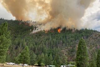
Thousands of Arizona residents fled a voracious wildfire Wednesday that has devoured a stretch of sparsely populated pinelands the size of Phoenix and shows no sign of stopping.
The Wallow fire, which began May 29, has blackened nearly 389,000 acres, making it the second-largest blaze in state history. It seemed poised to surpass the record-holder from 2002: Because of high winds and bone-dry terrain, the fire was 0% contained, meaning firefighters had not even begun to hem it in, much less get it under control.
Southeast Arizona’s topography is some of the most spectacular in the Southwest: a land of Zane Grey westerns, a rugged and steep landscape that rises to 11,000 feet. Nearby is evidence of human habitation stretching back 12,000 years.
Also in the area and threatened by the conflagration: power lines ferrying electricity from the Palo Verde nuclear plant near Phoenix to southern New Mexico and West Texas. An El Paso utility company warned its 372,000 customers of possible rolling blackouts if the lines burn.
Ferocious 35-mph winds were kicking embers as far as three miles past the edge of the main blaze. Smoke was visible as far away as Wyoming. With smaller, but still significant, blazes in the southern part of the state, 600 square miles of Arizona was ablaze Wednesday.
Only light winds were forecast for Thursday. But John Helmich, a spokesman for the incident command, warned, “Weather conditions are very volatile, and they can change very quickly.”
The blaze, which may have been sparked by an unattended campfire, tore through the evacuated town of Greer on Wednesday, forcing firefighters to flee, said Jim Whittington, spokesman for the Southwest interagency incident management team. Officials won’t know the extent of the damage until later.
In Springerville, at the edge of the blaze, evacuation orders came at 4:45 p.m. An eerie orange haze hung over town as cars streamed away from the pillar of smoke that was steadily closing in. Kathy Reidhead, 70, sat in the restaurant she co-owns there, eyes glued to the local news.
She fled her house in Nutrioso last week because of the fire, carrying her photos and landscape paintings. She was staying with one of her daughters and couldn’t imagine fleeing again.
“I’m not leaving here, because I’ve already been evacuated once,” she said wearily.
About 2,000 people are fighting the wildfire, including crews from as far away as New York state. Ken Frederick of the National Interagency Fire Center in Boise, Idaho, said 70% of the nation’s hot-shot fire teams are either in Arizona or central Alaska, where another fire is burning in an unpopulated area.
“It’s very difficult now because it’s so dry,” Frederick said. “Arizona is just bone-dry.”
Even as other parts of the country have been deluged with storms and floods, the Southwest has become a tinderbox. Due to the La Nina weather system, a vast stretch of the Southwest, from Arizona into West Texas and Oklahoma, is experiencing one of its driest years ever. Texas, too, has been plagued by massive wildfires this year.
The Wallow fire seemed unlikely to respect state lines. Residents in the western New Mexico town of Luna were warned they may have to evacuate.
As the fire moves east toward New Mexico it enters the historically rich Gila and Apache-Sitgreaves national forests, where scientists estimate there are several thousand archeological sites.
“That may be a low figure,” said Jim Bradford, regional supervisory archeologist for the National Park Service. The sites, which are defined by the physical remains of human activity, can be anything from a scattering of spear points to a multistory cliff palace. Archeologists have evidence of 12,000 years of human history in the area.
Although the sweeping White Mountains on the Arizona-New Mexico border are lightly peopled, they are a key playground for Arizona. For generations, families have sought refuge in the region’s hamlets and forests to escape the heat of Phoenix and Tucson. Among those who had to evacuate their vacation cabin near Greer on Saturday were U.S. Sen. John Kyl (R-Ariz.) and his family.
The area’s thick stands of ponderosa pine haven’t burned in more than a century, making them overripe for combustion, said Richard Minnich, a geography professor at UC Riverside.
Minnich, who studies fires, blamed a modern preference for extinguishing small wildfires, which leaves vast stands of flammable brush and timber. “Instead of just a modest amount of understory, you get more and more trees,” he said. “It just gets thick as a brick, and then the whole forest burns down.”
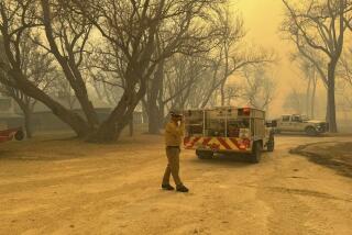
Firefighters spent much of Wednesday building containment lines around the towns of Eagar and Springerville. They used bulldozers to pulverize potential fuel and burned away vegetation to deprive the larger blaze of a path.
But embers jumped the fire lines and ignited brush in the canyons near the towns, leading the Apache County sheriff to order the evacuation. About 7,000 people live in the two communities, although nearly 2,000 had already fled southern Eagar and other hamlets.
By nightfall, only a few holdouts remained. Adam Widlowski, 46, was buying soda and cigarettes at the Springerville Circle K so he could hunker down in his trailer and wait out the fire. Almost all the other trailers, and the businesses around them, were dark. The only vehicles were sheriff’s cruisers and U.S. Forest Service trucks.
“I feel like the only person on Earth,” Widlowski said.
Powers reported from Springerville, Riccardi from Denver and Cart from Los Angeles.
More to Read
Start your day right
Sign up for Essential California for news, features and recommendations from the L.A. Times and beyond in your inbox six days a week.
You may occasionally receive promotional content from the Los Angeles Times.
