High resolution global maps show increasing forest loss in tropics
 The first fine-scale mapping of global forest cover shows the rate of forest loss in the tropics has increased over the past 12 years.
The use of remote sensing satellite data to chronicle changes in global land cover is not new. But in a paper published online this week in the journal Science, researchers provide an exceptionally detailed accounting of gains and loses in global forest cover from 2000 to 2012.
Matthew Hansen, a geographical sciences professor at the University of Maryland, led a group of 15 university, Google and government researchers who used Landsat data to map global tree cover at a spatial resolution of 98 feet.
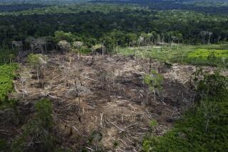
The images document the effects of forest disturbance - logging, wildfire, insect damage, storms – as well as forest regrowth. The total global loss in tree cover of 888,034 square miles was nearly three times the total gain during the period.
Of the world’s four climate zones -- tropical, subtropical, temperate and boreal -- the tropical was the only one to exhibit a statistically significant trend. Overall, forest loss in the tropics rose by 811 square miles a year.
The mapping confirmed that the forest clearing has slowed in Brazil, which experienced the largest decline in annual forest loss of any country. But as shown in the graphic above, annual tree loss in Indonesia more than doubled during the study period.
The world’s Far North boreal zone saw a mixture of loss and gain. Eurasian conifer forest cover increased with replanting, abandonment of agriculture and post-fire regrowth. But globally, Russia experienced the greatest forest loss (shown below), primarily as a result of wildfire.
The mapping was fine-grained enough to reflect regional disturbances, including the aftermath of a 2005 blowdown in the forests of southern Sweden and a 2009 windstorm that leveled extensive areas of trees in southwestern France.
Researchers processed more than 650,000 Landsat images to compile the database, which will be updated annually. It would have taken a single computer 15 years to do what was accomplished in a matter of days with Google Earth Engine computing.
Hansen, noting that Brazil has employed Landsat data to chronicle deforestation trends and set policy, said the global mapping will give every nation “access to this kind of information, for their own country and the rest of the world.”
 bettina.boxall@latimes.com
Twitter: @boxall


